 EPA-EFE/REX/Shutterstock
Valencia is still recovering from the first "Dana" weather system at the end of October
Two weeks after flash floods caused devastation in eastern Spain, several areas of the country are on alert, with a new weather front expected to bring torrential rain and low temperatures.
Eastern and southern Mediterranean areas are again the most vulnerable, with Spain's meteorological agency Aemet placing parts of the Valencia, Catalonia and Andalusia regions, as well as the Balearic Islands, on orange alert from now until Thursday.
Aemet warns of rainfall and storms that could be “very strong to torrential”.
That orange alert is the second highest and it signals a significant meteorological event “with a degree of danger for normal activities”.
A military vehicle has been driving through towns using a megaphone to warn of the expected storms.
Precautions are being taken in many areas of Valencia, with school classes and sports activities suspended in some towns and sandbags piled up to protect the centre of the town of Aldaia.
However this second “Dana” weather system is not expected to be as dramatic as the red alert on 29 October, when the Valencia region in particular suffered an unprecedented loss of lives and material damage.
There were 222 confirmed deaths from the flooding in Spain last month, and 23 people are still missing.
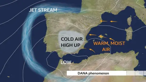
Dana weather systems are formed when an area of low pressure gets "cut off" from the main flow of the jet stream. This means that instead of moving through a region relatively quickly, they get blocked over the same area leading to persistent rainfall for several days.
Colder air high in the atmosphere meets warmer air flowing in from the Mediterranean which intensifies the storm.
Spain to get more intense rain this week
Heavy rainfall has already hit some areas this week.
Parts of Almería province in Andalusia were flooded on Monday night, causing part of the A7 motorway to be closed temporarily.
Emergency services rescued three people after their cars were dragged by the flood waters to a bridge in the town of Vícar.
The Spanish weather agency has advised people in areas on orange alert to stay away from ravines and waterways, even though they may be dry, because of the risk that they become flooded.
The national traffic office (DGT) advised people in those areas to check the state of roads before using vehicles.


Dana weather systems are not uncommon in Spain – they typically happen around 10 to 20 times a years in the western Mediterranean.
This second Dana in a matter of weeks is not considered either as extreme or slow-moving as the one that hit Valencia at the end of October.
However, the wettest places - especially around Malaga and Granada - could see around 180mm of rain falling this week – about two months’ worth of rainfall in a matter of days. Large hail and squally winds will also be a hazard.
The first significant snowfall of the season is expected to affect the Cantabrian mountains as well as the Sierra Morena mountains and the Central and Betic chains as colder air moves across the Peninsula.
Strong gusty winds will accompany the mountain snow too.

 1 month ago
5


 English (US) ·